|
Completed projects in Mexico:
In late fall of 2008, we
collected a suite of 35-40 mudstone samples from the uppermost part of
the latest Cretaceous Upper Potrerillos Mudstone that crops out in the
El Gordo minibasin of the La Popa basin in NE Mexico. These samples
were analyzed using vitrinite reflectance and revealed an unexpected,
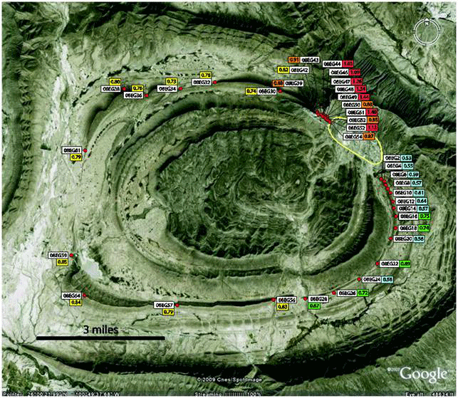
and highly asymmetrical, thermal anomaly. This page shows the location
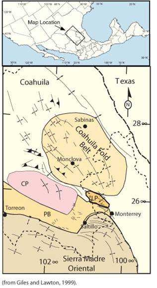
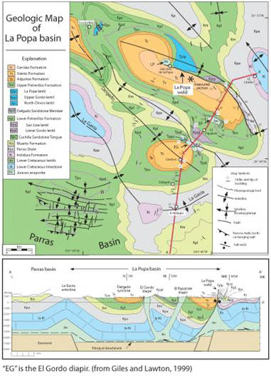
map of La Popa basin (labeled "LP"), a geologic map, and cross-section.
The El Gordo diapir is labeled "EG" on the map and is the southern
diapir on the cross-section. Vitrinite sample localities and results
are shown following the map images.
RESULTS
-
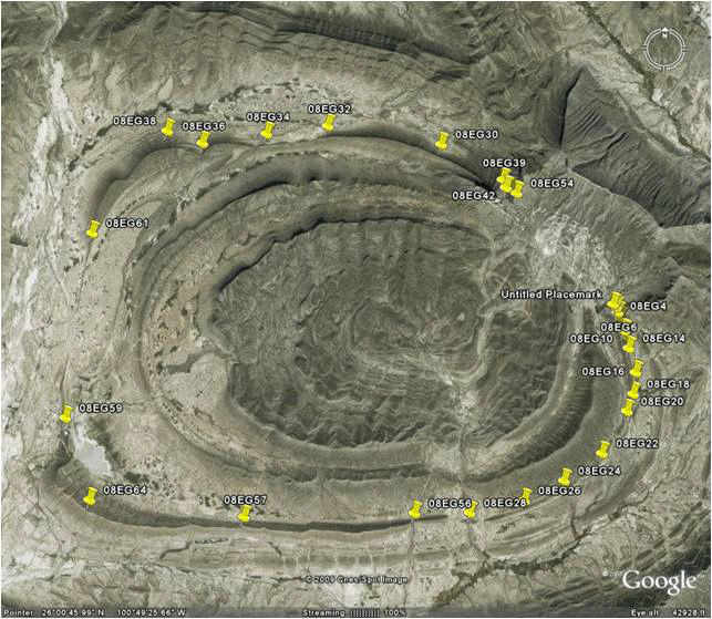
Google
Earth images of the El Gordo salt withdrawal minibasin showing sample
locations (upper) and vitrinite reflectance results (following figure).
The diapir is located in the upper right and is encircled by a yellow
line. Vitrinite values shown in yellow are presumed to be
representative of regional values; orange and red values occur near the
NW margin of the diapir and reach as high as 1.44 Ro; greens and blues
are cooler and reach a low of 0.50 Ro near the SE margin of the diapir.
We interpret high Ro values to represent elevated heat flow above an
inclined salt diapir that plunges to the northwest, and the low values
to the SE to be caused by an interpreted sub-diapir position. If our
interpretations are correct, then they invalidate the assumed vertical
orientation of the El Gordo diapir. If the diapir at El Papalote is
derived from a similar position at depth, then overturned halokinetic
sequences that crop out along the eastern edge of the diaper, which
have typically been ascribed to a ballooning of the diaper, may
actually be caused by the diapir over riding the strata. Another
important finding is that the scale of the anomaly is larger than what
numerical models predict.
-
Sandstone
samples of the K-T tsunami deposit known as the Delgado sandstone that
were collected from the same localities as our vitrinite samples in the
El Gordo minibasin (see previous figure) were analyzed using QEMSCAN,
an automated SEM with backscatter chemical analysis and via standard
petrography. Given the wide variability in vitrinite values that we
documented in the adjacent Lower Potrerillos Mudstone, we hypothesized
that:
-
these reservoir analogue sandstones experienced different
diagenetic histories, and that samples from areas that had depressed
vitrinite results did not undergo quartz cementation whereas those from
areas that had high vitrinite values would have significant amounts of
quartz overgrowths. We impregnated samples with blue epoxy and analyzed
them using QEMSCAN and standard petrography. What we found were that
samples contained primarily calcite cement or original fine-grained
matrix material between the framework grains. We found essentially no
quartz cementation in any of the Delgado Sandstone samples based on the
QEMSCAN results as well as via standard petrographic analysis.
-
that feldspar compositions would vary depending on location;
that those from regions that had lower vitrinite values would contain a
greater variety of feldspar compositions and that those from areas with
higher vitrinite values would have feldspars with more albitic
composition. Our results showed no significant variation in feldspar
composition across the entire basin.
-
that ankerite cements might be present in the area that had
high vitrinite values. The QEMSCAN data revealed no ankerite cements
anywhere in our samples.
-
We
began using remote sensing methods to model modern heat flow around
exposed diapirs. Our initial efforts were around the Ribera Alta diapir
in northern Spain as well as on the El Gordo diapir in La Popa basin,
NE Mexico. This project used remotely sensed thermal data collected in
areas adjacent to the diapir and compared them to areas with similar
geology but where no salt structures are present. The data were modeled
in order to remove diurnal, seasonal, glacial-interglacial heat fluxes
in order to assess any modern-day thermal variability around the salt
structure. This work was part of Nick Downs M.S. thesis which is
located elsewhere on the website. In short, remote sensing efforts on
the Ribera Alta diapir were inconclusive because of the abundant
vegetation in the area. However, significant thermal signatures were
modeled at La Popa; see Nick’s thesis for full details. Dr. Scott
Nowicki supervised this portion of the project.
ONGOING/FUTURE
WORK
-
We are in the beginning
stages of separating clay mineral species from our Potrerillos Mudstone
samples for subsequent XFD analysis. Previous research has shown that
original smectitic clays undergo dehydration reactions as temperatures
increase and that they convert to illite. Our hypothesis is that
smectite/illite ratios may change depending on the proximity to the
diaper. We will prepare and run the samples in UNLV’s XXL: XRF/XRD lab.
|