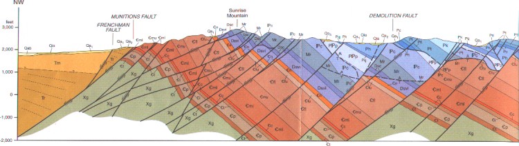
Cross-section by James E. Faulds
Below is a brief review of the history of geologic research at Frenchman Mountain and a list of key references.
The geology of the Frenchman Mountain-Rainbow Gardens area was first mapped in the mid-twentieth century by Chester Longwell, the pioneer of Southern Nevada geology. Longwell's mapping was published in 1965 on the 1:250,000 scale geologic map of Clark County that accompanies the Nevada Bureau of Mines and Geology county bulletin (Longwell et al., 1965), the publication that remains the standard reference on Clark County geology. The Frenchman Mountain-Rainbow Gardens area was also described and illustrated in John Shelton's popular 1966 textbook Geology Illustrated, and the Frenchman Mountain Paleozoic section was included as one of the 100 best and most accessible, regionally significant sites in the Geological Society of America's Cordilleran Section Centennial Field Guide (Rowland, 1987). Through these publications, and numerous field trips and regional field guides, the main features of the geology of Frenchman Mountain became known to many geologists and geology students throughout the 1960s, '70s, and '80s.
Meanwhile, in the 1980s Southern Nevada (along with adjacent portions of Arizona and California) had become a focus of the study of extensional tectonics. A landmark study by Robert Bohannon (1984) revised the stratigraphic nomenclature of the Miocene Horse Spring Formation, which occurs throughout the Lake Mead region. Because the Horse Spring Formation was deposited during the Miocene Epoch, when this region was being tectonically pulled apart, Bohannon's study of Horse Spring Formation stratigraphy provided critical data for reconstructing the Miocene tectonic history of the Lake Mead region, including the Frenchman Mountain block. Bohannon (1984), among many other things, defined four members of the Horse Spring Formation. These are, from oldest to youngest, Rainbow Gardens Member, Thumb Member, Bitter Ridge Limestone Member, and Lovell Wash Member. The older two of these members had formerly been called the Thumb Formation by Longwell. Castor et al. (2000) further subdivided the Thumb and Rainbow Gardens members into several map units on their published geologic map of the Frenchman Mountain Quadrangle.
In 1990, Brian Wernicke edited a Geological Society of America book titled Basin and Range extensional tectonics near the latitude of Las Vegas, Nevada. This book, along with an earlier GSA Bulletin paper by Wernicke et al. (1988), captures the status of geologic research in Southern Nevada in 1990 concerning extensional tectonics. One chapter in this book (Rowland et al., 1990) is devoted to the tectonic history of the Frenchman Mountain Block; the authors concluded that Frenchman Mountain moved about 80 km (or about 50 miles) to the west between about 10 million and 6 million years ago, in the Miocene Epoch. For a very crude cartoon summary of how this movement is inferred to have taken place, see How to Move a Mountain. The detachment fault that is inferred to exist somewhere beneath Frenchman Mountain in this model was not detected by Langenheim et al., (2001)(see below). This doesn't necessarily mean that the fault isn't there, but it may require a re-evaluation of this model and the depth of the inferred detachment fault.
 Although Longwell's mapping of Frenchman Mountain has been available since 1965 on the Bulletin 62 map (Longwell et al., 1965). The scale of that map (1:250,000) is too small to be useful for detailed work. Essentially a reconnaissance map, it is generally correct but very often wrong in detail. In 1993 a 1:24,000 scale geologic map of the Las Vegas Northeast 7˝' quadrangle, which contains the western face of Frenchman Mountain, was published (Matti et al., 1993). A geologic map of the Frenchman Mountain 7˝' quadrangle was published in 2000 (Castor et al., 2000), together with a lengthy description of the structural geology and economic geology of the quadrangle. These 7˝' maps can be ordered online from the Nevada Bureau of Mines and Geology.
An important geophysical study of Las Vegas Valley, which bears on the geologic history of Frenchman Mountain, was conducted by USGS geophysicist Vicki Langenheim and her colleagues (Langenheim et al., 2001), as part of the USGS's Las Vegas Urban Corridor/Nevada Test Site project. For the latest results of this project, see the project Web site.
References
Bohannon, R.G., 1984, Nonmarine sedimentary rocks of Tertiary age in the Lake Mead Region, southeastern Nevada and northwestern Arizona: U.S. Geological Survey Professional Paper 1259, 72 p.
Castor, S.B., Faulds, J.E., Rowland, S.M., and dePolo, C.M., 2000, Geologic Map of the Frenchman Mountain Quadrangle, Clark County, Nevada: Nevada Bureau of Mines and Geology Map 127, scale 1:24,000.
Langenheim, V.E., Grow, J.A., Jachens, R.C., Dixon, G.L., and Miller, J.J., 2001, Geophysical constraints on the location and geometry of the Las Vegas Valley shear zone, Nevada: Tectonics, v. 20, p. 189-209.
Longwell, C.R., Pampeyan, E.H., Bowyer, B., and Roberts, R.J., 1965, Geology and Mineral Deposits of Clark County, Nevada. Nevada Bureau of Mines and Geology, Bulletin 62, 218 p., with 1:250,000 scale geologic map.
Matti, J.C., Castor, S.B., Bell, J.W., and Rowland, S.M., 1993, Geologic Map of the Las Vegas NE Quadrangle, Clark County, Nevada: Nevada Bureau of Mines and Geology Map 3Cg, scale 1:24,000.
Rowland, S.M., 1987, Paleozoic stratigraphy of Frenchman Mountain, Clark County, Nevada, in Hill, M.L., ed., Centennial Field Guide: Geological Society of America, Cordilleran Section, v. 1, p. 53-56.
Rowland, S.M., Parolini, J.R., Eschner, E., McAllister, A.J., and Rice, J.A., 1990, Sedimentologic and stratigraphic constaints on the Neogene translation and rotation of the Frenchman Mountain structural block, Clark County, Nevada, in Wernicke, B.P., ed., Basin and Range extensional tectonics near the latitude of Las Vegas, Nevada: Geological Society of America Memoir 176, p. 99-122.
Shelton, J.S., 1966, Geology Illustrated: Freeman, San Francisco, 434 p.
Wernicke, B., editor, 1990, Basin and Range extensional tectonics near the latitude of Las Vegas, Nevada: Geological Society of America Memoir 176.
Wernicke, B., Axen, G.J., and Snow, J.K., 1988, Basin and Range extensional tectonics at the latitude of Las Vegas, Nevada: Geological Society of America Bulletin, v. 100, p. 1738-1757.


