SILVVER 2003:

Seismic Investigation of Las Vegas Valley: Evaluating Risks


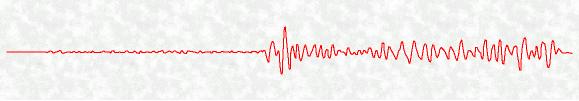
Jornada shot recorded at Squires Park, Las Vegas, NV

Regional Map Purpose Contact Info  Acknowledgments
Background Methods  Press Release  Results and Models

Background

A recent FEMA report (2000) listed that if a large magnitude earthquake were to hit the Las Vegas metropolitan area that there would be an annualized loss of $28 million.  "Legacy" data (recorded when Nevada Test Site was active) and recent geologic and geophysical studies have shown that there are at least eight active tectonic faults throughout the Las Vegas basin, which have the potential of producing a magnitude 6.5-7 earthquake (Slemmons et al., 2001). 

These data also show that the basin has varying amplification factors and the potential to focus energy with strong ground shaking (Figure 1) (Su et al., 1998).  The strong ground shaking causes the majority of damage during an earthquake, so it is imperative to understand how the Las Vegas basin will respond to such motion.  The potential to have earthquakes occurring within the basin as well as strong ground shaking from a distant earthquake (<200 km epicentral distance) increases seismic risk potential to the city of Las Vegas.  This risk is much higher than previous estimates. 

Acquiring additional geophysical data within the valley will provide answers to key questions such as why there is such a variability in amplification across the basin and define any new structures such as sub-basins within the valley, which may focus energy. 


Purpose

The Las Vegas Basin Seismic Experiment of Summer 2003 is designed to further  assess the seismic hazard of the Las Vegas region.  The data collected during the deployment will help expand our understanding of the basin's geometry and provide vauluable information for the future of Las Vegas and its development.  Data will be used in conjuction with many other data sets to futher our understanding of the Las Vegas Valley and how it will react to earthquakes, both large magnitude and small.

Updated SILVVER Map

Regional map of Las Vegas Valley, Nevada and surrounding features. 
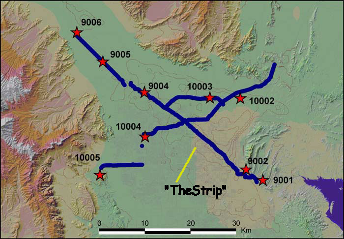
Updated map of the SILVVER '03 showing deployment of Texan as well as Shot point locations.  Blue line represents the deplyments locations of the Texans.  The red stars represent the shot point locations.

Methods

The experiment was conducted over a 4 day period whereby the seismic instruments werel deployed around the area with the help of many volunteers from the community.  Controlled explosions were set off sometime after midnight on the 12th of August.  In all 9 shots were detonated at approxiamately 10 minuet intervals. 


Results and Models


Contact Info For more information please contact Dr. Cathy Snelson, Assistant Professor of Geophysics, UNLV at (702)895-2916 or via email at csnelson@unlv.nevada.edu

Press Release

"All Shook Up? Nevada is one of the nation's most seismic states. Las Vegas is undercut with fault lines. Should we be rattled?" - Las Vegas Weekly,Weekly, June 26 - July 2, 2003

"Study increases damage estimate for major quake" - Las Vegas Review-Journal, May 2, 2003

"Threat of quakes appears greater" - Las Vegas Sun,May 1, 2003

"Scinetist plottting 'shake map'" - Las Vegas Review-Journal, July 30, 2003


Acknowledgments

SILVVER '03 Project:  Special thanks to IRIS Passcal instrument center at UTEP for providing seismic refraction instruments.  Many thanks to the volunteers who helped in deploy the Texans.  Those include Amy Brock, Darlene McEwan, Anna Draa, Shelley Zaragoza, Andrew Hanson, Darren Burgett, Rudy Foresta, Sandra Saldana-Farkas, John Sandru, Aaron Hirsch, Ying Liu, Nicole Nastanski, Jared Lubben, Joe Kula, Eric Fossett, John Van Hoesen, Lucky Wenzel, Kuwanna Dyer, Jeremy Koonce, Sam Hudson, Patrick Drohan, Joy Drohan, Xiahui Jin, Tiana Rasmussen, Matt Clark, Adam Hemsley, Warren Dang, Matt Averill, Leandro Trevino, Annette Veilleux, Eva Rumphuber, Roane Nue, Lugman Adams, John Harris, Victor Galvan, Tamara Mosley, Sarah Cervera,  David Fortenberry, Oscar Esparza, Jim Iholts, Iskra Zamarron, Enrique Casana, Steve Holloway, Toby Toybgel, Brinda Thomas, Alexis Cartwright-Taylor, Tom Draa, Greg Smith, Galen Kaip, Steve Azevedo, William McKibben, Steve Harder, and several others.  Thanks to the homeowners who housed instruments.  Thanks to the BLM, Greater Las Vegas Auto auction, Desert Sportsman's Rifle club, UNLV, City of Las Vegas and North Las Vegas.  Thanks to City of Las Vegas and North Las Vegas, and the Clark County Fire departments.  Thanks to Allen Drilling and Sanders construction.  Thanks to Artie Rodgers and Dave McCallen for mobilizing the deployment for the broadband stations.  Thanks to Pat, Don, and Duane for helping install the sites.  Thanks to the Clark County School district and Nellis Airforce base.  Additional support from the UTEP Landmark Computer Facility. These projects are funded by Lawrence Livermore National Lab, U. S. Geological Survey  NEHRP, and UNLV.


More Information


Living with Earthquakes in Nevada

Earthquakes in Nevada and how to survive them

Questions and Answers on Earthquakes in Nevada


Funding Agencies


UNLV Geoscience Home Page

Las Vegas Seismic Response Project Home Page