Chapter 8
(Gravity)
Gravity
Gravity on a small scale:
Attractive Force (Newton’s Law): ![]()
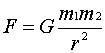 Where: m1 and m2 are
small masses; r is the separation G is the Gravitiational constant = 6.672 x
10-8 m3/mg.s2
Where: m1 and m2 are
small masses; r is the separation G is the Gravitiational constant = 6.672 x
10-8 m3/mg.s2
Gravity
on Earth
The
calculation is based on point masses, therefore assuming the earth has
concentric layers we can say me is the center and ms is
at its surface separated by Re and can use Newtons law:
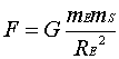
In
terms of acceleration this equation becomes:
![]()
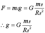
Where: g = accelaeration due to gravity
Mass of the earth
Using
equation 8.4 we can calculate the mass of the earth:
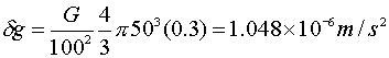
Ø We have found that the average mass is 5.5 Mg/m3
Ø Because rock at the surface are much less
(generally < 3.0 Mg/m3) we know the center of earth is more dense
Densities
of Rocks: Rock densities are
typically less at the surface than at depth. This is due to weathering and
fracturing.
Units
of density:
Ø Mg/m3
Ø g/cc, which compares to the density of water
(~1)
Ø kg/m3,
which is 1000x larger
Gravity
units:

Given
the example in the book (Eq. 8.5):
These
units are too small so we use mGal instead:
![]()
where: ![]()
![]()
Gravity anomalies of some
bodies
Calculating gravity anomalies:
Calculated
using vectors summed as per the pull on the mass to the surrounding area
(measuring the excess).
Sphere
and Cylinder:
Ø At depth there will be no sharp edges
Ø The anomaly will be more defined the closer to
the surface it is
Sheets:
Sheetlike
bodies include dikes, sills (slab) or veins; again more
definition, the shallower the feature.
If
a slab produces no anomaly, it’s excess density will increase “g” by an amount
that can be calculated by:
![]()
where:
t is the thickness of the slab
Calculations
are usually accomplished by breaking shapes into smaller sections. This allows us to model the anomaly more
easily.
Measuring Gravity:
The Gravimeter
3
ways to do this:
1)
Measure the time it
takes for an object to fall
2)
Use a pendulum
3)
Use a spring
balance
Modern
meters can measure changes in “g” as small as a hundredth of mGal or 10-8g.
Data
Reduction:
–
Measuring lateral
variations of “g”
–
Always start at a base
station where the value of “g” is known
–
Conversion of the readings
depends on the meter
Types
of conversions:
Drift: caused by
slow creep of the spring and tidal variations, which can be up to 0.3mGal in a
day. Drift is measured by returning to
the base station throughout the day.
Latitude:
equatorial bulge created by the rotation of the earth
–
We can correct for
latitude effects by using the International Gravity Formula
![]()
–
For a surveyor that is
<10's of km variations can be proportional to the distance:
![]() polewards; where l is the latitude where the survey is being made
polewards; where l is the latitude where the survey is being made
Eötvös correction:
typically associated with shipborne or airborne surveys
![]() ; where v is
the speed (kph), l is the latitude and a is the direction of travel (measured clockwise)
; where v is
the speed (kph), l is the latitude and a is the direction of travel (measured clockwise)
Topography correction:
1)
Free-air
correction: need for position in spave of the gravimeter (affected by a rise in
cm’s)
2)
Bouguer correction:
corrects for pull of rock bodies in the surrounding area
![]()
–
Because both Free-air and
Bouguer corrections are dependent on “h” the equations can be combined:
![]()
3)
Terrain correction:
This takes into account the changing topography in a survey area
–
Once all the corrections
are made the anomaly is called a Bouguer Anomoly
Bouguer Anomoly =
observed “g” + free-air correction – Bouguer correction + terrain correction –
latitude correction + Eötvös correction
Simple Bouguer:
lacks terrain correction (if very small)
*
Purpose: to produce a value of “g” without the effects of topography and
latitude
Residual and regional anomalies: at depth we try to separate anomalies. This is done so that we can discern
different features. The residual
anomaly is subtracted from the total anomaly.
Like in the example for the book, subtractins out the residual for the
regional, the residual is the dike. The
regional is the granite and surrounding rocks.
Surveys
Planning a survey
1)
want to define a
target
2)
Need to determine
the precision (e.g., 10mGal anomaly need precision to 1mGal and heights need to
be known to about 30 cm)
3)
The survey should
be longer than the feature
4)
To increase
accuracy you need to visit a base station often
5)
Ideally we would
like to get an in situ measurement of density.
Alternatively, we can use Garnders Rule for estimating velocity to
density
Marine
surveys:
–
Average readings over time
–
Eötvös correction
–
Usually these surveys are
no better than 1mGal (this can be obtained with Satellite gravity surveys)
–
In deep water (no Bouguer
correction); resulting anomaly is a “free-air anomaly”
Airborne
surveys:
–
Accuracy is 5 to 20 mGal
–
Good for areas with access
issues
Modelling and Inversion
*Gravity
models are commonly non-unique solutions (you can come up with a variety of
models for the same data).
*Because we are measuring density contrasts it is essential to use
the known geology as a starting or reference for density modeling.
Depth
rules:
The
sharpness of a measurement or gradient tells you that there is the boundary of
an object. This sharpness is measured
as half width. Fig 8.19 in your text
gives you some rule for half-width calculations. If the shape is unknown, the steepest slope is used and the total
height of the anomaly. When modeling,
the bodies are defined as polygons with uniform densities.
Total
excess mass:
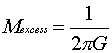 (Volume of the anomaly); or you can
use:
(Volume of the anomaly); or you can
use: 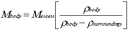
![]()
Microgravity:
Ø Used to target anomalies of <0.1 mGal
Ø Typically used for environmental or civil
engineering projects
Ø Can look for gaps or holes (caves)
![]()
![]()